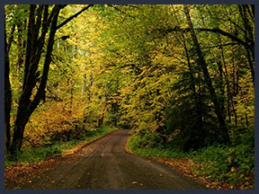
SCENIC DRIVES
Many people of all abilities can enjoy a scenic forest road drive including rugged back country, untamed rivers and majestic mountains.
Be Prepared Driving Forest Roads
Before heading out on your scenic back road adventures check with the Darrington Ranger Station for snow levels and road conditions. It is always a good idea to purchase a Darrington Ranger District Map that shows you all of the Forest Service Roads. When heading out for a back road drive be sure to let someone know where you are heading out to. If you hit snow you have likely reached the snow line level and it will only get deeper! Good rule to follow for snow driving is always turn around while you can and not when you have to! By then it may be to late and it is a long walk out. There is very little cell service in the back country. Be prepared and bring food, blankets and always bring plenty of water both for you and in case your vehicle overheats. These remote back roads make you feel like you are the only one out driving that road but you will encounter other drivers and even log trucks at times. Watch ahead for oncoming traffic and keep an eye out for the wide spots along the road called "turn outs" where you can pull over and let the other vehicle pass. Every road is a unique discovery of seasonal changes from summer wildflowers to autumn colors, views of the mountains and the wildlife you may encounter. |
Mountain Loop Highway
Rugged peaks and deep, abundant forests beckon the adventurous traveler along the Mountain Loop Scenic Byway. The 55 mile route leads into the heart of the Cascades along the scenic Sauk and Stilliguamish River corridors in the Mt. Baker-Snoqualmie National Forest. Along “the Loop” you will follow the waterways traveled by the Sauk-Suiattle tribe in shovel nosed canoes and retrace the steps of intrepid miners, loggers and CCC “Boys” as they attempted to carve out a living in the vast wilderness.
The Mountain Loop Scenic Bway can be accessed by way of the City of Granite Falls from the south or through the Town of Darrington from the north. Both are full serivce communities so, be sure your gas tank is full and you have hiking and picnic supplies for your drive. There is NO cell phone service once you begin your journey.
Cumberland Pass
To start your scenic back road drive up to Cumberland Pass, drive about 5 miles west from Darrington on SR 530, turn right onto Swede Heaven Rd, drive 1.5 miles, turn right on FS Rd. #18. You are beginning to drive up Mt. Higgins via Segeleson Ridge.When you have driven 12.7 miles on FS Rd. #18 you will see your first glimpse of Segelsen Lake on the right. At this point the surrounding vegetation seems to undergo a magical transformation of lush alpine wildflowers. A little after passing the lake, keep right at the "Y," and then at 13.4 miles you will come to the first waterfall lacing the rock faces to the right of the road. To continue turn left up the mountain. When you reach 24.1 miles turn left onto FS Rd. #17. You will reach the beautiful Cumberland Pass at 33.2 miles. You can see two huge rock formations with alpine marshes on both sides of the road. This is when you want to pull over and take your time. Everywhere you look nature has crafted gardens of rock and water. Wildflowers and butterflies are abundant.
Cougar Hollow
To get to Cougar Hollow, drive south from town towards the Mountain Loop Highway, and then make a left onto the White Chuck Bridge. This will put you on Forest Service Road #022. Drive past the raft launching area and rest room and up the hill about three miles. When you come to the intersection where FS #24 goes right and FS #22 goes left, keep left driving down towards the Sauk River. Shortly after passing FS #2420 you will wind downhill to FS #22 also called the North Sauk River Road. At this intersection if you look to the left, you will see where the old road has been rerouted and there is a great spur for a primitive campsite. The North Sauk River Rd. is to your right.
Gold Hill's Scenic Loop
The Gold Hill Scenic Loops Starts from driving south from Darrington to the White Chuck Bridge. Crossing the bridge onto Forest Rd. # 22 driving 2.9 miles to Forest. Rd. #24. This is where we need to zero the odometer for our scenic drive. As you continue to climb higher views of Prairie Mountain open up. You will come to the junction of FS. Rd. #2420 to the left or take the straight route remaining on FS. Rd. #24 driving 2.6 miles to Sauk Prairie and back to town. If you continue on the FS. Rd #2420 which is a rougher road, you will meet back up at the junction of FS. Rd. #24 where you started at about 4.5 miles. Views of Whitehorse to the west and Darrington down in the valley open up. Just as you begin to descend Gold Hill there is a landing where you can get out and stretch your legs. There is a great view looking southwest of Jumbo Mountain & beyond.
White Chuck Ridge
One way to get to White Chuck Ridge is to go to the White Chuck Bridge and Rafting Launch south of Darrington towards the Mountain Loop Highway. Cross the bridge, this will put you on Forest Service Road #023 which will take you to Gold Hill, drive up this road until you reach the intersection of Forest Service Road #24, make a left onto FS #24 and drive until you meet FS #2430, this will take you to FS #2035 which is a pretty constant climb to Decline Creek.
The Waterfall Drive
This is an easy drive with 4 waterfalls, and several additional smaller waterfalls. We start our trip heading south towards the Mountain Loop Highway from Darrington, mileage begins from the "Welcome To Darrington Sign" and Clear Creek Road is to your left. Driving south on the Mountain Loop Highway at 6.7 miles, during the early summer snow melt, you will see "First Falls" just to your right as you drive. Continuing on this waterfall tour, just before you reach 12.8 miles you will see a turn out so you can park to enjoy 3 waterfalls to the left of the road. At 15.5 miles you will turn left on FS Rd. #49 "Sloan Creek Rd.", and drive 1 mile to the parking area on the right for North Fork Sauk Falls trailhead #660. There is a short .2 mile hike descending down 200 feet to the waterfall #5, a truly amazing waterfall that you will likely hear from the trailhead as the river is forced through a narrow gorge as the river makes a 49 foot drop. To continue your drive on the waterfall trail, backtrack to the Mountain Loop Highway turning right and heading north, drive 7 miles to the White Chuck Bridge, turn right over the bridge, this puts you on FS Rd. #23 at the White Chuck Boat Launch. A vaulted toilet is located here. Continue to drive about 3 miles to the intersection with FS Rd. #24 to the right and FS Rd. #22 to the left. Keep to the left on #22 driving downhill towards the Sauk River. Shortly after passing FS Rd. #2420 the road will bend to the right and run along the Sauk River. This is a short drive due to a washout which is barricaded, before this point you will find 2 larger and several smaller waterfalls. To continue on the waterfall trail return back to the Mountain Loop Highway crossing over the White Chuck Bridge heading north (right) and drive 5 miles to and turn left on FS Rd. #2060, and drive 2 3/4 miles to the last waterfall, Asbestos Creek Falls, (just before Asbestos Creek Falls is one more unnamed waterfall). Right before reaching the falls is a wide spot to park and turn back around. Asbestos Creek Falls is 950 feet high with the largest single drop of 150 feet.
Sloan Creek Road
What make the Sloan Creek scenic drive a unique destination is this is the only drive where you will see the beautiful North Fork Sauk River. There several places to pull over along this wild river and enjoy a picnic. Get out and stretch your legs with two short easy day hikes to huge majestic cedar trees and a 60 foot waterfall! We begin our drive by turning off the Mountain Loop Highway. The road gradually climbs through forested land. At mile 1.2 you will see the turnout for the North Fork Sauk Falls. The 0.2 mile trail descends 200 feet to a great view of the waterfall. You can hear the waterfall from the road and sometimes see the mist rising from the tremendous force of the NF Sauk River as it is forced through the narrow canyon below. Continuing past the trailhead on your drive at miles 2.6 you will come to a turnout along the road with a very nice view of the river. When you reach miles 2.7 look up the slopes of Bedal Peak to the right where a creek makes several drops forming waterfalls. At miles 3.0 you will reach another turnout where the river forms deep pools and a sandy bank. This area is a popular primitive camping site. You will see the Lost Creek Ridge trailhead to the left as you reach miles 3.1. This is a longer day hike and backpacking trail with several steep switchbacks eventually bringing you to the ridge above and amazing views! At miles 3.4 you will reach your second day hike, The Harold Engles Memorial Grove. The trailhead is on the right and you will see the trail dropping down the bank to the trees below. This is an easy loop trail with very little elevation gain. You will reach a Y in the road at miles 6.8, the road to the left goes to N. Sauk Trail and the one to the right is Sloan Creek road and goes to the Bald Eagle Trailhead also known as Curry Gap. After driving almost .5 miles you will come to the trailhead where there is a foot bridge to the trail over beautiful Sloan Creek, NF Sauk River's biggest tributary. There is a vaulted toilet at the trailhead. Please keep in mind that a federal recreation pass is required to use this trailhead.
Rat Trap Pass Loop
From the Darrington Ranger Station drive south toward the Mountain Loop Highway. At miles 2.1 note the labyrinth of beaver ponds to the left. At miles 3.3 you will see the Clear Creek Campground to the left and forest road #2060 to the right. Continuing on your drive you will see First Falls, a seasonal waterfall, to the right at miles 7.6 and pass forest road #2080, the road to the Peek-A-Boo Lake trail head at miles 9.2. When you reach miles 10 you will see the Beaver Lake trail head to the right and the White Chuck Bridge with White Chuck Mountain in the background. The road crossing the bridge is the route for other scenic forest road drives, Gold Hill Loop, Cougar Hollow and White Chuck Ridge. A little past the bridge you will see White Chuck Rd. #23 coming up on the left where you will turn left to continue your drive. This road travels along the wild White Chuck River with beautiful views of White Chuck Mountain and several lovely creeks and streams along the way. Continuing on you drive you will begin to descend Rat Trap Pass at 21 miles, sometimes you can see the 3 upper Rat Trap Falls on White Chuck Mountain ahead of you as they drop from White Chuck lake. When you reach miles 21.5 you will reach 40 foot Rat Trap Falls. You will soon be seeing the approach of the famous Boundary Bridge as it crosses the Suiattle River. Once crossing the bridge turn left onto the Suiattle River Road, #26. As you continue driving this road will reach pavement. You are now headed west and back toward SR 530 & Darrington.
WILDFLOWERS
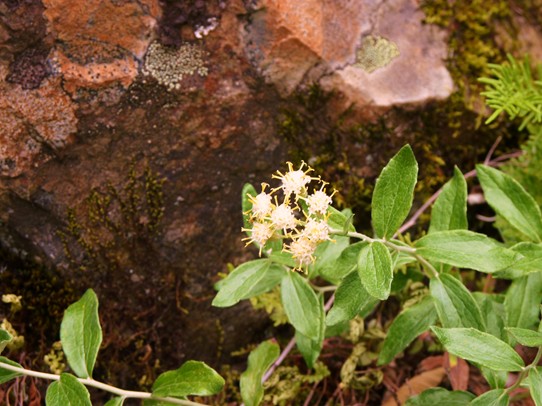
Luina hypoleuca, Silver-Back
You will find Luina hypoleuca growing in rock crevices, as it is very tolerant of dry hot conditions. These unusually sturdy flowers begin to bloom in late July. The common name Silver-Back refers to the fact that the leaves are green with a finely haired and pale silver color below. The flowers grow in upright clusters of 10 to 20 florets on stems about 8 to 14 inch stems. This is a good late flower to see on the Old Penn Mining Road going to Goat Lake and the Old Government Trail.
March – September


