MOUNTAIN BIKING TRAILS
North Mountain Bike Trails
In partnership with Evergreen Mountain Bike Alliance, the Darrington community, legislative leaders, and Washington's outdoor recreating public, DNR is developing a mountain bike trail system on North Mountain. About an hour from Everett, the trail system offers breathtaking views of Whitehorse Mountain and the Stillaguamish Valley.
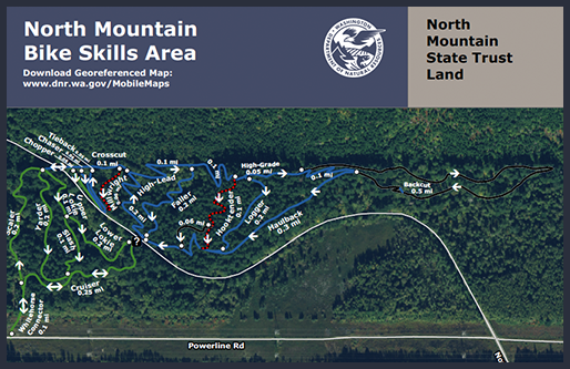 North Mountain Skills Area: About 4 miles of lower elevation trails in our North Mountain Bike Skills Area offer family friendly riding year round and opportunities for beginner and intermediate riders. In the future, an additional 13 miles of trail will reach further up North Mountain to access terrain for more experienced riders.
Chocwich Mountain Bike Trail
Goat Lake: Follow the Upper Elliot Creek Trail straight ahead from the trailhead. Continue one mile and turn left at the junction to follow the Chockwich Trail.
Bedal: The trail is an old roadbed traversing mid-slope between Bedal Creek and the Upper Elliot Creek Trail. Begin at Bedal Creek Trailhead and cross Bedal Creek in a fourth of a mile at a campsite. The ford can be difficult, especially early in the season. The ford at Chockwich creek can also be difficult in high runoff conditions. Continue downward through big timber, transitioning into small alder groves and openings with views of the upper Sauk Valley until reaching the junction with Upper Elliot Creek Trail 647 at 2,200 feet. Bicycles are only allowed on Upper Elliot Creek Trail. Lower Elliot Creek Trail is not a bike trail and the Goat Lake Trail enters Henry M. Jackson Wilderness where only foot traffic is permitted.
AT A GLANCE
Usage: Light
Best Season: Spring/Summer/Fall
Closest Towns: Darrington, Washington
Information Center: Check current conditions or call Darrington Ranger District office at (360)436-1155 or Verlot Public Service Center at (360)691-7791.
DIRECTIONS
Goat Lake Side Trailhead Access 1: From the Verlot Public Service Center (11 miles east of Granite Falls, WA) travel east on Mt. Loop Highway 22.8 miles to Elliot Creek Road (Forest Service road 4080). Turn right and continue 0.8 miles to the trailhead.
Goat Lake Side Trailhead Access 2: From Darrington Ranger District office travel south along Mt. Loop Highway 20 for 22 miles to Elliot Creek Road (Forest Service road 4080). Turn left and continue 0.8 miles to the trailhead.
Bedal Side Trailhead Access 1: From the Verlot Public Service Center (11 miles east of Granite Falls, WA) travel east on Mt. Loop Highway 26 miles to Forest Service road 4096. Turn right and continue two miles to the trailhead.
Bedal Side Trailhead Access 2: From Darrington Ranger District office travel south along Mt. Loop Highway 20 for 21 miles to Forest Service road 4096. Turn left and continue two miles to the trailhead.
Click for Darrington Area Gravel Bike Routes
Click for Darrington Mountain Bike Park
WILD FLOWERS
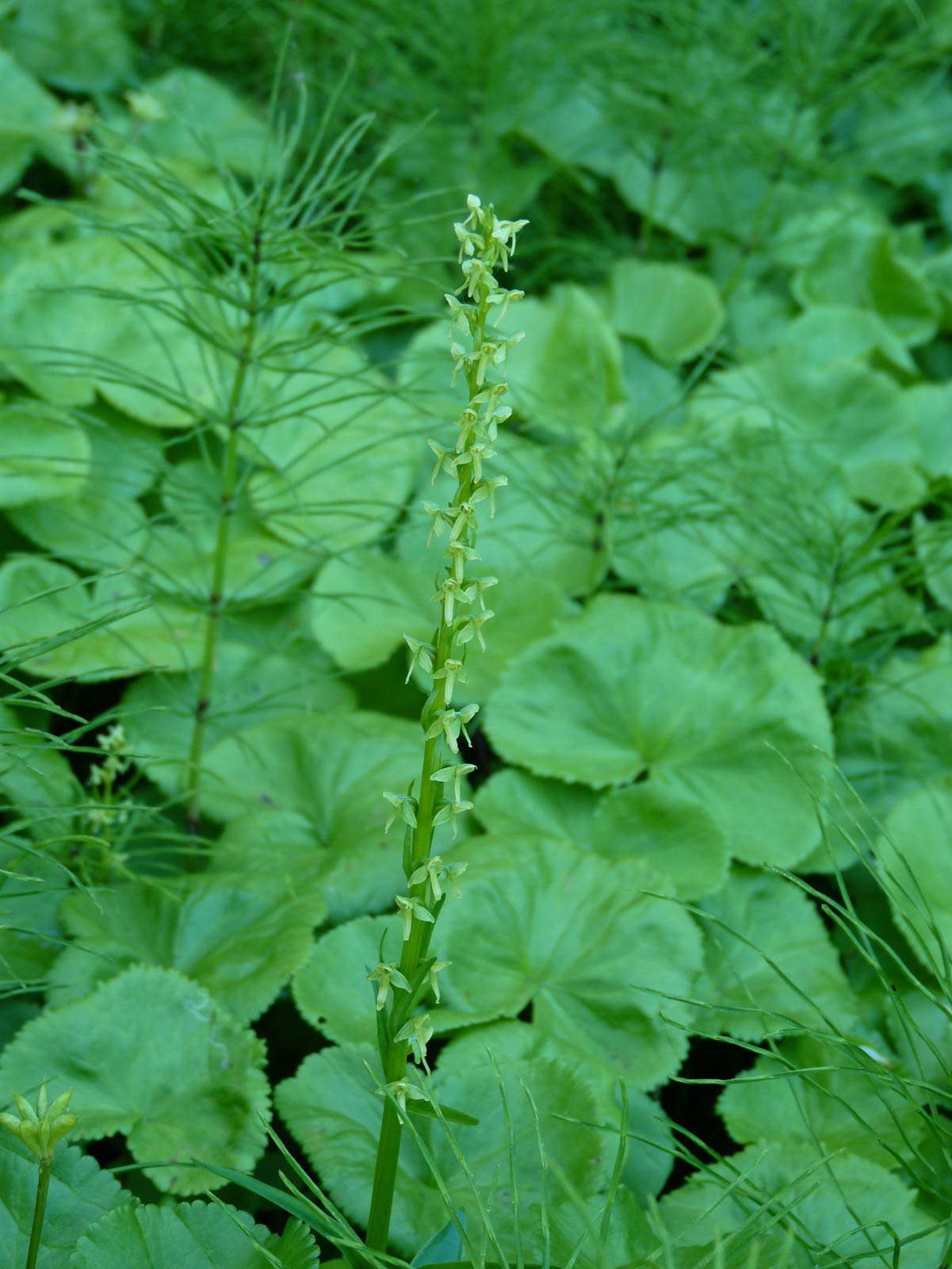
Bracted Rein-Orchid
This intricate woodland orchid because of the greenish colored flowers, bracts and leaves, will many times go unnoticed blending into it's surroundings. This is a common flower to see growing in alpine marshes and the shores of alpine lakes often with Mountain Marsh Marigold blooming from the end of May through August. It grows 12 to 18 inches tall and as it ages many times it will develop a green-bronze color. A good place to view Bracted Rein-orchid is Tupso Lake, Peek-A-Boo Lake Trail and the Cumberland Pass and White Chuck Ridge scenic drives.
May – September


